Posted on Category: dataset, Dataset_Software China Vegetation Products version 1.0 (CVP v1.0)

China Vegetation Products version 1.0 (CVP v1.0)

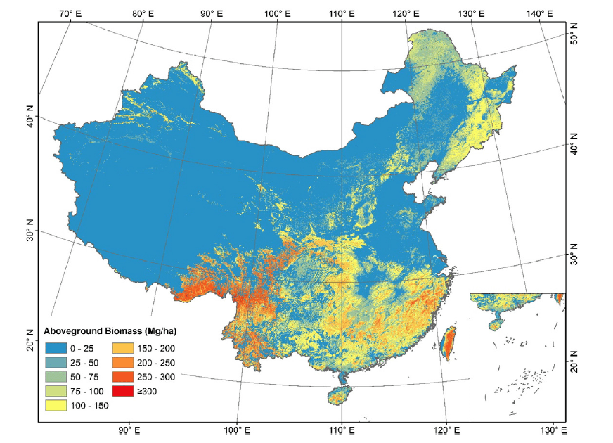
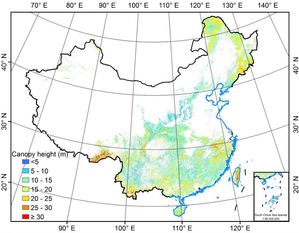
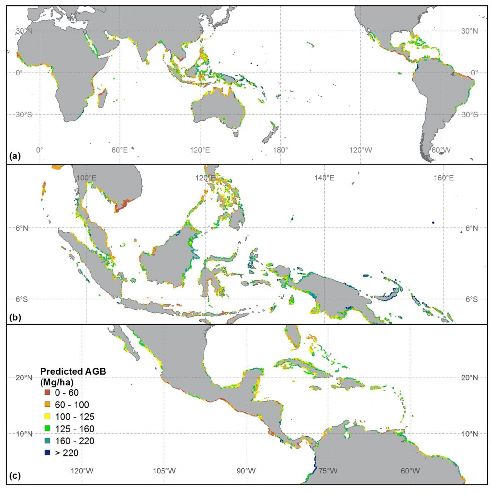
Vegetation is a crucial component of ecosystems, playing a vital role in maintaining biodiversity, regulating climate, and protecting soil and water resources. As one of the countries with the most diverse vegetation types in the world, China’s vegetation resources carry significant ecological functions and environmental benefits. In recent years, due to both natural and human […]

Posted on Category: dataset, Dataset_Software China’s planted forest maps from 1990 to 2020

China’s planted forest maps from 1990 to 2020

Tree planting has been suggested as a potentially effective solution for mitigating climate change. China has implemented the world’s largest afforestation and reforestation project since the 1970s, but high-resolution maps of China’s planted forests remain unavailable. In this study, we explored the use of multi-source remote sensing images and crowdsourced samples to produce the first high-resolution […]

Posted on Category: Projects Environmental Change and Terrestrial Ecosystem Response

Environmental Change and Terrestrial Ecosystem Response

Environmental Change and Terrestrial Ecosystem Response Changes of forest quality are composed by the changes in forest structure and species composition, which are usually caused by tree growth, anthropogenic activities (e.g., forest treatment, logging), and environmental disturbances (e.g., drought, flood, and wildfire). To quantitatively assess forest structure changes from multitemporal lidar data, we proposed an […]

Comments Off on Environmental Change and Terrestrial Ecosystem ResponseCategory: Projects
Posted on Category: dataset, Dataset_Software Global forest woody residence time in 2004

Global forest woody residence time in 2004

Global forest woody residence time by random forest method Woody residence time is an important parameter that expresses the balance between mature forest recruitment/growth and mortality. Using field data collected from the literature, our group explored the global forest τw and investigated its influence on model simulations of aboveground biomass (AGB) at a global scale. […]

Posted on Category: dataset, Dataset_Software China forest AGB map(2019)

China forest AGB map(2019)

Forest aboveground biomass (AGB) estimation is crucial for carbon cycle studies and climate change mitigation actions. However, because of limitations in timely and reliable forestry surveys and high-resolution remote sensing data, producing a fine resolution and spatial continuous forest AGB map of China is challenging. Here, we combined 4789 ground-truth AGB measurements and multisource remote […]

Posted on Category: News Forest tree height map of China

Forest tree height map of China

Spatially continuous estimates of forest canopy height at national to global scales are critical for quantifying forest carbon storage, understanding forest ecosystem processes, and developing forest management and restoration policies to mitigate global climate change. Spaceborne light detection and ranging (lidar) platforms, especially the Global Ecosystem Dynamics Investigation (GEDI) and Ice, Cloud, and land Elevation […]

Comments Off on Forest tree height map of ChinaCategory: News
Posted on Category: dataset, Dataset_Software Benchmark dataset for airborne lidar scanning data filtering in forested environments

Benchmark dataset for airborne lidar scanning data filtering in forested environments

Data description: Airborne laser scanning (ALS) data is one of the most commonly used data for terrain products generation. Filtering ground points is a prerequisite step for ALS data processing. Because canopy cover and terrain slope are various in forested environments, filtering in forested environments is more challenging than filtering in other environments, such as […]

Comments Off on Benchmark dataset for airborne lidar scanning data filtering in forested environmentsCategory: dataset, Dataset_Software
Posted on Category: dataset, Dataset_Software Global mangrove forest AGB map

Global mangrove forest AGB map

Mangrove forest ecosystems are distributed at the land–sea interface in tropical and subtropical regions and play an important role in carbon cycles and biodiversity. Accurately mapping global mangrove aboveground biomass (AGB) will help us understand how mangrove ecosystems are affected by the impacts of climatic change and human activities. Light detection and ranging (LiDAR) techniques […]

Posted on Category: News Forest tree height across the Sierra Nevada

Forest tree height across the Sierra Nevada

Forests of the Sierra Nevada (SN) mountain range are valuable natural heritages for the region and the country, and tree height is an important forest structure parameter for understanding the SN forest ecosystem. There is still a need in the accurate estimation of wall-to-wall SN tree height distribution at fine spatial resolution. In this study, […]

Comments Off on Forest tree height across the Sierra NevadaCategory: News
Posted on Category: dataset, Dataset_Software Corrected SRTM DEM

Corrected SRTM DEM

SRTM (shuttle radar topography mission) DEM (digital elevation model) is a near-global terrain product with high accuracy, and has been widely used in many researches, such as hydrological survey, geological hazards assessment, and ecological protection. However, it has been proved that SRTM DEM is systematic higher than the real ground truth in vegetation regions, as […]