Supported by the National Key Basic Research Program of China (project number 2013CB956604), National Science Foundation of China (project numbers 41471363, 31270563 and 41401505), and National Science Foundation (DBI 1356077), our group developed a new method to retrieve gap fraction, clumping index and leaf area index using the point cloud data generated from terrestrial laser scanner (TLS), the corresponding results are published in the journal of ISPRS Journal of Photogrammetry and Remote Sensing.
In this study, we developed a new method to retrieve gap fraction according to the Scanning characteristics of TLS, and proposed a new clumping index retrieval algorithm, and finally retrieved leaf area index based on gap fraction theory. Ground validation data were collected by destructively sampling 35 trees and measuring all their leaves. Results show that the TLS-based “true” LAI estimations based on a single TLS scan are strongly correlated with the destructively sampled LAI measurements (R2 = 0.76, RMSE = 0.47).
The primary author of this paper is Yumei Li (Ph.D. candidate), and Corresponding author is Prof Qinghua Guo. Links as follows: http://www.sciencedirect.com/science/article/pii/S0924271616304130。

Figure 1. The scheme of single-station scanning and the slicing of point cloud data in terms of different incident zenith angles θ

Figure 2. Point cloud data of an individual-tree and schematic diagram for estimating the clumping index.

Figure 3. Scatter plots showing the 1:1 relationship between the terrestrial laser scanning-based effective leaf area index (LAI) and destructive-sampling measured LAI
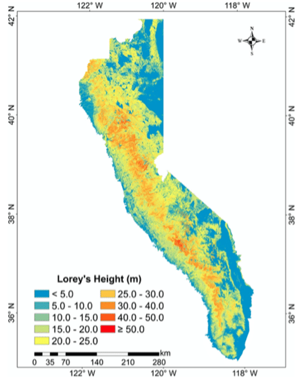 Forest tree height across the Sierra Nevada-1