3D forest structure parameter extraction and upscaling

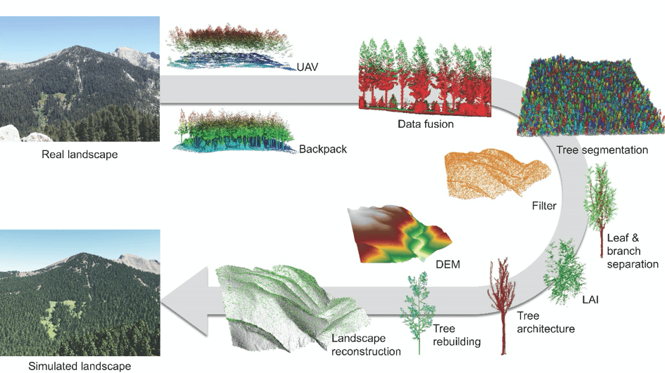
Individual trees are the basic element composition of a forest stand. The structure characteristic and spatial distribution of trees are the key factors to be surveyed in forest inventory. Lidar, as an emerging active remote sensing technology, provides an automatic, effective and accurate tool for deriving individual tree parameters. However, lidar data are composed of numerous unordered points, and identifying individual trees from them becomes an important but required first step for extracting forest structure parameters from lidar data. To solve this issue, we proposed a novel individual tree segmentation principle, which is based on the ecological metabolic theory and graph theory, and uses the spatial connectivity and density information to extract individual trees from lidar point clouds directly (Li et al., 2012; Jakubowski et al., 2013; Lu et al., 2014; Tao et al., 2015; Yang et al., 2019). Based on extracted individual tree point clouds, we further developed algorithms to extract essential structural parameters of concern in forest inventory (e.g., tree height, diameter at breast height, crown base height, crown volume, crown diameter, leaf area index, crown architecture traits, and biomass) hinging on the photogrammetry theory, graph theory, machine learning technique, and deep learning technique (Jakubowski et al., 2013; Tao et al., 2014; Tao et al., 2015; Su et al., 2016; Li et al., 2016; Zhao et al., 2016; Li et al., 2017; Su et al., 2017; Ma et al., 2017; Li et al., 2018; Luo et al., 2018; Li et al., 2020). Using the above-mentioned lidar-derived fine-scale forest parameters, we further developed a method to upscale forest inventory parameters through the fusion of multiplatform and multisource remote sensing data, which can largely reduce the “saturation effect” of traditional upscaling method only based on optical remote sensing data (Xue et al., 2017). This method has been successfully used to generate terrain elevation, tree height and biomass products from landscape to regional, national and global scales (Tao et al., 2014; Su et al., 2014; Li et al., 2015; Su et al., 2015; Su et al., 2016; Hu et al., 2016; Su et al., 2017; Guo et al., 2017; Zhao et al., 2018), which provide important data support for forest management and ecological monitoring.

Publications​

  1. Li Wenkai, Guo Qinghua*, Jakubowski Marek K., Kelly Maggi. 2012. A New Method for Segmenting Individual Trees from the Lidar Point Cloud. Photogrammetric Engineering And Remote Sensing.78(1):75-84.
  2. Jakubowski Marek K., Guo Qinghua, Kelly Maggi. 2013a. Tradeoffs between lidar pulse density and forest measurement accuracy. Remote Sensing of Environment. 130:245-253.
  3. Lu Xingcheng, Guo Qinghua*, Li Wenkai, Flanagan Jacob. 2014. A bottom-up approach to segment individual deciduous trees using leaf-off lidar point cloud data. ISPRS Journal Of Photogrammetry And Remote Sensing. 94:1-12.
  4. Tao Shengli, Wu Fangfang, Guo Qinghua*, Wang Yongcai, Li Wenkai, Xue Baolin, Hu Xueyang, Li Peng, Tian Di, Li Chao, Yao Hui, Li Yumei, Xu Guangcai, Fang Jingyun. 2015a. Segmenting tree crowns from terrestrial and mobile LiDAR data by exploring ecological theories. ISPRS Journal of Photogrammetry and Remote Sensing. 110: 66-76.
  5. Yang Qiuli, Su Yanjun, Kelly Maggi, Hu, Tianyu, Ma Qin, Li Yumei, Song Shilin, Zhang Jing, Xu Guangcai, Wei Jianxin, Guo Qinghua*. 2019. The influences of vegetation characteristics on individual tree segmentation methods with airborne LiDAR data. Remote Sensing. 11:2880.
  6. Jakubowksi Marek K., Guo Qinghua, Collins Brandon, Stephens Scott, Kelly Maggi. 2013b. Predicting Surface Fuel Models and Fuel Metrics Using Lidar and CIR Imagery in a Dense, Mountainous Forest. Photogrammetric Engineering And Remote Sensing. 79(1):37-49.
  7. Jakubowski Marek K., Li Wenkai, Guo Qinghua, Kelly Maggi. 2013c. Delineating Individual Trees from Lidar Data: A Comparison of Vector- and Raster-based Segmentation Approaches. Remote Sensing. 5(9):4163-4186.
  8. Tao Shengli, Guo Qinghua*, Li Le, Xue Baolin, Kelly Maggi, Li Wenkai, Xu Guangcai, Su Yanjun. 2014. Airborne Lidar-derived volume metrics for aboveground biomass estimation: A comparative assessment for conifer stands. Agricultural and Forest Meteorology. 198:24-32.
  9. Tao Shengli, Guo Qinghua*, Xu Shiwu, Su Yanjun, Li Yumei, Wu Fangfang. 2015b. A Geometric Method for Wood-Leaf Separation Using Terrestrial and Simulated Lidar Data. Photogrammetric Engineering & Remote Sensing. 81(10): 767-776.
  10. Li Yumei, Guo Qinghua*, Tao Shengli, Zheng Guang, Zhao Kaiguang, Xue Baolin, Su Yanjun. 2016. Derivation, Validation, and Sensitivity Analysis of Terrestrial Laser Scanning-Based Leaf Area Index. Canadian Journal of Remote Sensing. 42(6):719-729.
  11. Su Yanjun, Guo Qinghua*, Collins Brandon M., Fry Danny L., Hu Tianyu, Kelly Maggi. 2016a. Forest fuel treatment detection using multi-temporal airborne lidar data and high-resolution aerial imagery: a case study in the Sierra Nevada Mountains, California. International Journal of Remote Sensing.37(14):3322-3345.
  12. Zhao Xiaoqian, Guo Qinghua*, Su Yanjun, Xue Baolin. 2016. Improved progressive TIN densification filtering algorithm for airborne LiDAR data in forested areas. ISPRS Journal of Photogrammetry and Remote Sensing. 117:79-91.
  13. Li Yumei, Guo Qinghua*, Su Yanjun, Tao Shengli, Zhao Kaiguang, Xu Guangcai. 2017. Retrieving the gap fraction, element clumping index, and leaf area index of individual trees using single-scan data from a terrestrial laser scanner. ISPRS Journal of Photogrammetry and Remote Sensing. 130:308-316.
  14. Su Yanjun, Ma Qin, Guo Qinghua*. 2017a. Fine-resolution forest tree height estimation across the Sierra Nevada through the integration of spaceborne LiDAR, airborne LiDAR, and optical imagery. International Journal of Digital Earth. 10(3):307-323.
  15. Ma Qin, Su Yanjun, Guo Qinghua*. 2017a. Comparison of Canopy Cover Estimations From Airborne LiDAR, Aerial Imagery, and Satellite Imagery. IEEE Journal of Selected Topics in Applied Earth Observations and Remote Sensing. 10(9):4225-4236.
  16. Luo Laiping, Zhai Qiuping, Su Yanjun, Ma Qin, Kelly Maggi, Guo Qinghua. 2018. Simple method for direct crown base height estimation of individual conifer trees using airborne LiDAR data. Opt Express.26(10):A562-A78.
  17. Li Yumei, Su Yanjun*, Hu Tianyu, Xu Guangcai, Guo Qinghua*. 2018. Retrieving 2-D Leaf Angle Distributions for Deciduous Trees From Terrestrial Laser Scanner Data. IEEE Transactions on Geoscience and Remote Sensing. 56(8):4945-4955.
  18. Li Yumei, Su Yanjun, Zhao Xiaoxia, Yang Mohan, Hu Tianyu, Zhang Jing, Liu Jin, Liu Min, Guo Qinghua. 2020. Retrieval of tree branch architecture attributes from terrestria llaser scan data using a Laplacian algorithm. Agricultural and Forest Meteorology. 284: 107874.
  19. Xue BaoLin, Guo Qinghua*, Hu Tianyu, Wang Guoqiang, Wang Yongcai, Tao Shengli, Su Yanjun, Liu Jin, Zhao Xiaoqian. 2017a. Evaluation of modeled global vegetation carbon dynamics: Analysis based on global carbon flux and above-ground biomass data. Ecological Modelling. 355:84-96.
  20. Su Yanjun, Guo Qinghua*. 2014. A practical method for SRTM DEM correction over vegetated mountain areas. ISPRS Journal Of Photogrammetry And Remote Sensing. 87:216-228.
  21. Li Le, Guo Qinghua*, Tao Shengli, Kelly Maggi, Xu Guangcai. 2015. Lidar with multi-temporal MODIS provide a means to upscale predictions of forest biomass. ISPRS Journal of Photogrammetry and Remote Sensing. 102:198-208.
  22. Su Yanjun, Guo Qinghua*, Ma Qin, Li Wenkai. 2015. SRTM DEM Correction in Vegetated Mountain Areas through the Integration of Spaceborne LiDAR, Airborne LiDAR, and Optical Imagery. Remote Sensing.7(9):11202-11225.
  23. Su Yanjun, Guo Qinghua*, Xue Baolin, Hu Tianyu, Alvarez Otto, Tao Shengli, Fang Jingyun. 2016b. Spatial distribution of forest aboveground biomass in China: Estimation through combination of spaceborne lidar, optical imagery, and forest inventory data. Remote Sensing of Environment. 173:187-199.
  24. Hu Tianyu#, Su Yanjun#, Xue Baolin, Liu Jin, Zhao Xiaoqian, Fang Jingyun, Guo Qinghua*. 2016. Mapping Global Forest Aboveground Biomass with Spaceborne LiDAR, Optical Imagery, and Forest Inventory Data.Remote Sensing. 8(7):1-27.
  25. Guo Qinghua*, Su Yanjun, Hu Tianyu, Zhao Xiaoqian, Wu Fangfang, Li Yumei, Liu Jin, Chen Linhai, Xu Guangcai, Lin Guanghui, Zheng Yi, Lin Yiqiong, Mi Xiangcheng, Fei Lin, Wang Xugao. 2017b. An integrated UAV-borne lidar system for 3D habitat mapping in three forest ecosystems across China. International Journal of Remote Sensing.38(8-10):2954-2972.
  26. Zhao Xiaoqian, Su Yanjun, Hu Tianyu, Chen Linhai, Gao Shang, Wang Rui, Jin Shichao, Guo Qinghua*. 2018. A global corrected SRTM DEM product for vegetated areas. Remote Sensing Letters. 9(4):393-402.