Geographic One-class Data: Methods & Applications

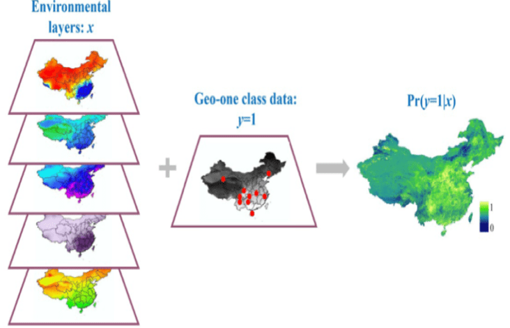
We are interested in the theory and applications of geographic one-class data. One common problem with geographic data is that, for a specific geographic event, only occurrence information is available; information about the absence of the event is not available. We define these specific types of geospatial data as geographic one-class data (GOCD) (Guo, et al, 2011). Predicting the potential spatial distributions that a particular geographic event may occur from GOCD is difficult because traditional binary classification methods require the availability of both positive and negative training samples. Our research focuses on developing new GOCD methods and their applications to human and environmental systems (e.g., species distribution, remote sensing classification, search and rescue in National Parks, and landslides). 

One specific GOCD method is environmental niche modeling, which aims to map the potential distribution of species given presence-only observation data. With the increasing availability of ecological data, environmental niche modeling has gained much attention for a wide variety of ecological applications. However, one major obstacle to fully exploring the wealth of the data is that they often contain presence data and no absence data, which makes traditional statistical learning methods unsuitable for modeling them. We proposed the use of a one-class support vector machine to model presence-only species data (Guo et al., 2005). We developed a novel niche modeling approach: a positive unlabeled algorithm (Li et al. 2011). In addition, we have developed a comprehensive platform that integrates a range of state-of-the-art niche modeling methods within a geographical information system (Guo & Liu, 2010). The platform (http://gis.ucmerced.edu/ModEco/) has been downloaded and used in research projects by more than 500 universities, institutes, and organizations in North America, South America, Europe, and Asia.

Publications

  1. Guo Qinghua*, Li Wenkai, Liu Yu, Tong Daoqin. 2011. Predicting potential distributions of geographic events using one-class data: concepts and methods. International Journal Of Geographical Information Science. 25(10):1697-1715.
  2. Guo Qinghua*, Kelly Maggi, Graham Catherine H. 2005. Support vector machines for predicting distribution of sudden oak death in California. Ecological Modelling. 182(1):75-90.
  3. Li Wenkai, Guo Qinghua*, Elkan Charles. 2011. A Positive and Unlabeled Learning Algorithm for One-Class Classification of Remote-Sensing Data. IEEE Transactions on Geoscience and Remote Sensing.49(2):717-725.
  4. Guo Qinghua*, Liu Yu. 2010. ModEco: an integrated software package for ecological niche modeling. Ecography. 33(4):637-642.
  5. Doherty Paul, Guo Qinghua*, Liu Yu, Wieczorek John, Doke Jared. 2011. Georeferencing Incidents from Locality Descriptions and its Applications: a Case Study from Yosemite National Park Search and Rescue. Transactions in Gis. 15(6):775-793.
  6. Doherty Paul, Guo Qinghua, Alvarez Otto. 2013. Expert versus Machine: A Comparison of Two Suitability Models for Emergency Helicopter Landing Areas in Yosemite National Park. Professional Geographer.65(3):466-481.
  7. Li Wenkai, Guo Qinghua*. 2013. How to assess the prediction accuracy of species presence–absence models without absence data? Ecography. 36:001–012.
  8. Li Wenkai, Guo Qinghua*. 2014. A New Accuracy Assessment Method for One-Class Remote Sensing Classification. IEEE Transactions on Geoscience and Remote Sensing. 52(8):4621-4632.
  9. Guo Qinghua*, Li Wenkai, Liu Desheng, Chen Jin. 2012. A Framework for Supervised Image Classification with Incomplete Training Samples. Photogrammetric Engineering And Remote Sensing. 78(6):595-604.
  10. Wieczorek John, Guo Qinghua, Hijmans Robert. 2004. The point-radius method for georeferencing locality descriptions and calculating associated uncertainty. International Journal Of Geographical Information Science. 18(8):745-67.
  11. Guo Qinghua*, Liu Yu, Wieczorek J. 2008. Georeferencing locality descriptions and computing associated uncertainty using a probabilistic approach. International Journal of Geographical Information Science. 22(10):1067-1090.
  12. Liu Yu, Guo Qinghua*, Wieczorek John, Goodchild Michael F. 2009. Positioning localities based on spatial assertions. International Journal Of Geographical Information Science. 23(11):1471-1501.