Vegetation is a crucial component of ecosystems, playing a vital role in maintaining biodiversity, regulating climate, and protecting soil and water resources. As one of the countries with the most diverse vegetation types in the world, China’s vegetation resources carry significant ecological functions and environmental benefits. In recent years, due to both natural and human factors, China’s vegetation has undergone significant changes. Against the backdrop of global climate change, obtaining accurate vegetation data for China is particularly urgent. This is not only essential for scientific understanding and monitoring of China’s ecological environment but also imperative for effectively addressing climate change, protecting biodiversity, and achieving sustainable development goals.
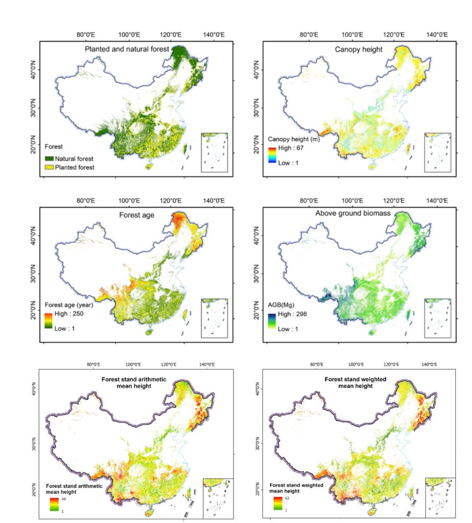
In response to these imperatives, we have leveraged cutting-edge artificial intelligence methodologies, encompassing advanced deep learning and machine learning algorithms. Our approach incorporates an extensive dataset comprising over 400 terabytes of near-ground LiDAR data and hundreds of thousands of ground survey data points. Through this concerted endeavor, we have achieved the generation of a suite of spatiotemporally coherent data products delineating the spatial distribution of vegetation across China, which is named China Vegetation Products (CVP). The data product set being released this time is version 1.0, targeting the forest ecosystem in China, including time series planted and natural forest maps from 1990 to 2020, forest canopy height map in 2019, forest age map in 2020, aboveground biomass maps for forests in 2019 and 2004, forest stand arithmetic mean height map in 2020, forest stand weighted mean height map in 2020, etc. The research findings related to this dataset have been published in internationally renowned journals such as “Remote Sensing of Environment“, “ISPRS Photogrammetry and Remote Sensing“, “Earth System Science Data“, “GIS Science and Remote Sensing“, etc. This dataset can provide scientific support for understanding the ecological benefits of Chinese forests and achieving China’s dual carbon goals.
Reference:
Su Yanjun, Guo Qinghua, Xue Baolin, Hu Tianyu, Alvarez Otto, Tao Shengli, Fang Jingyun. 2016. Spatial distribution of forest aboveground biomass in China: Estimation through combination of spaceborne lidar, optical imagery, and forest inventory data. Remote Sensing of Environment, 173, 187-199
Liu Xiaoqiang, Su Yanjun, Hu Tianyu, Liu Bingbing, Deng Yufei, Tang Hao, Tang Zhiyao, Fang Jingyun, Guo Qinghua. 2022. Neural network guided interpolation for mapping canopy height of China’s forests by integrating GEDI and ICESat-2 data. Remote Sensing of Environment. 269:112844.
Cheng Kai, Su Yanjun, Guan Hongcan, Tao Shengli, Ren Yu, Hu Tianyu, Ma Keping, Tang Yanhong, Guo Qinghua. 2023. Mapping China’s planted forests using high resolution imagery and massive amounts of crowdsourced samples. ISPRS Journal of Photogrammetry and Remote Sensing. 196, 356-371.
Yang Qiuli, Niu Chunyue, Liu Xiaoqiang, Feng Yuhao, Ma Qin, Wang Xuejing, Tang Hao, Guo Qinghua. 2023. Mapping high-resolution forest aboveground biomass of China using multisource remote sensing data. GIScience & Remote Sensing. 60(1), 2203303.
Cheng Kai, Yang Haitao, Guan Hongcan, Ren Yu, Chen Yuling, Chen Mengxi, Yang Zekun, Lin Danyang, Liu Weiyan, Xu Jiachen, Xu Guangcai, Ma Keping, Guo Qinghua. 2024. Unveiling China’s natural and planted forest spatial-temporal dynamics from 1990 to 2020, ISPRS Journal of Photogrammetry and Remote Sensing. 209: 37-50.
Cheng Kai, Chen Yuling, Xiang Tianyu, Yang Haitao, Liu Weiyan, Ren Yu, Guan Hongcan, Hu Tianyu, Ma Qin, Guo Qinghua. 2024. A 2020 forest age map for China with 30 m resolution. Earth System Science Data. 16: 803-819.
Chen Yuling#, Yang Haitao#, Yang Zekun, Yang Qiuli, Liu Weiyan, Huang Guoran, Ren Yu, Cheng Kai, Xiang Tianyu, Chen Mengxi, Lin Danyang, Qi Zhiyong, Xu Jiachen, Zhang Yixuan, Xu Guangcai, Guo Qinghua. 2024. Enhancing High-Resolution Forest Stand Mean Height Mapping in China through an Individual Tree-Based Approach with Close-Range LiDAR Data. Earth System Science Data. 16: 5267-5285.