Vegetation is a crucial component of ecosystems, playing a vital role in maintaining biodiversity, regulating climate, and protecting soil and water resources. As one of the countries with the most diverse vegetation types in the world, China’s vegetation resources carry significant ecological functions and environmental benefits. In recent years, due to both natural and human […]
Environmental Change and Terrestrial Ecosystem Response
Environmental Change and Terrestrial Ecosystem Response Changes of forest quality are composed by the changes in forest structure and species composition, which are usually caused by tree growth, anthropogenic activities (e.g., forest treatment, logging), and environmental disturbances (e.g., drought, flood, and wildfire). To quantitatively assess forest structure changes from multitemporal lidar data, we proposed an […]
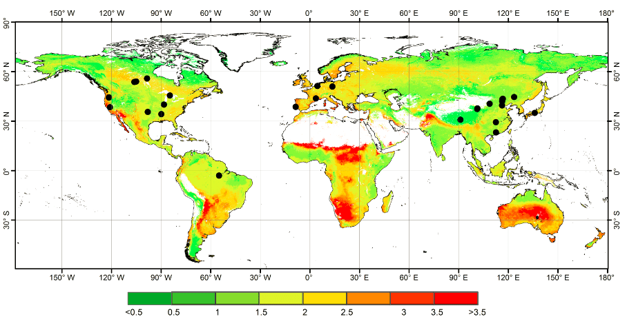
Global forest woody residence time in 2004
Global forest woody residence time by random forest method Woody residence time is an important parameter that expresses the balance between mature forest recruitment/growth and mortality. Using field data collected from the literature, our group explored the global forest τw and investigated its influence on model simulations of aboveground biomass (AGB) at a global scale. […]
Benchmark dataset for airborne lidar scanning data filtering in forested environments
Data description: Airborne laser scanning (ALS) data is one of the most commonly used data for terrain products generation. Filtering ground points is a prerequisite step for ALS data processing. Because canopy cover and terrain slope are various in forested environments, filtering in forested environments is more challenging than filtering in other environments, such as […]
Global mangrove forest AGB map
Mangrove forest ecosystems are distributed at the land–sea interface in tropical and subtropical regions and play an important role in carbon cycles and biodiversity. Accurately mapping global mangrove aboveground biomass (AGB) will help us understand how mangrove ecosystems are affected by the impacts of climatic change and human activities. Light detection and ranging (LiDAR) techniques […]
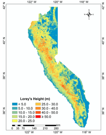
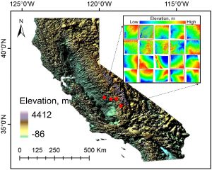
Forest tree height across the Sierra Nevada
Forests of the Sierra Nevada (SN) mountain range are valuable natural heritages for the region and the country, and tree height is an important forest structure parameter for understanding the SN forest ecosystem. There is still a need in the accurate estimation of wall-to-wall SN tree height distribution at fine spatial resolution. In this study, […]
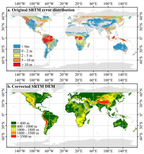
Corrected SRTM DEM
SRTM (shuttle radar topography mission) DEM (digital elevation model) is a near-global terrain product with high accuracy, and has been widely used in many researches, such as hydrological survey, geological hazards assessment, and ecological protection. However, it has been proved that SRTM DEM is systematic higher than the real ground truth in vegetation regions, as […]
Global forest woody residence time
Woody residence time is an important parameter that expresses the balance between mature forest recruitment/growth and mortality. Using field data collected from the literature, our group explored the global forest τw and investigated its influence on model simulations of aboveground biomass (AGB) at a global scale. We estimated the global 1 km τw using a random forest […]
Global forest AGB map
Global forest ecosystems form a large carbon pool, and are a critical component of the global carbon cycle. Accurate estimations of global forest aboveground biomass (AGB) will improve understanding of global carbon dynamics and help quantify anthropogenic carbon emissions. Light detection and ranging (LiDAR) techniques have been proven to accurately capture both horizontal and vertical […]
ModEco
ModEco is a software package for ecological niche modeling. It integrates a range of niche models within a geographical information system. ModEco provides a user friendly platform that enables users to explore, analyze, and model species distribution data with relative ease. It contains a suite of functions such as data input/output, data visualization, feature analysis, […]